Natural Navigation Explained: Scan Matching vs Feature Matching
Vehicle automation projects succeed or fail on the strength of their navigation technology. That’s why robust and flexible natural navigation technologies are a popular choice for companies automating industrial vehicles.
In this article, we explore the difference between the two main types of natural navigation technologies (sometimes called free navigation) for AGVs – scan matching and feature matching – along with their respective pros and cons.
In this article
- What’s the difference between scan matching and feature matching?
- Can a vehicle navigate accurately without seeing everything?
- Where are an AGV’s navigation scanners located?
- Is internet connectivity required for AGVs using natural navigation?
- Which is more accurate – scan matching or feature matching natural navigation?
- If a vehicle ignores dynamic parts of the environment, will that cause collisions?
- Which natural navigation technology should you choose?
What’s the difference between scan matching and feature matching?
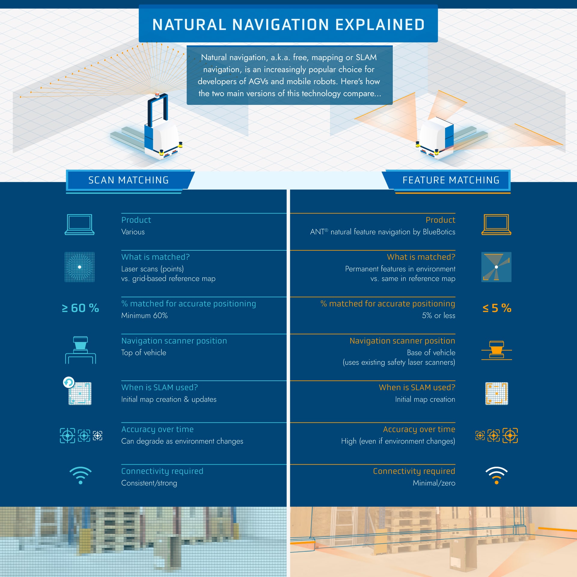
Put simply, today’s natural navigation technologies use one of two different methodologies: scan matching (sometimes called SLAM navigation) and feature matching (used by ANT).
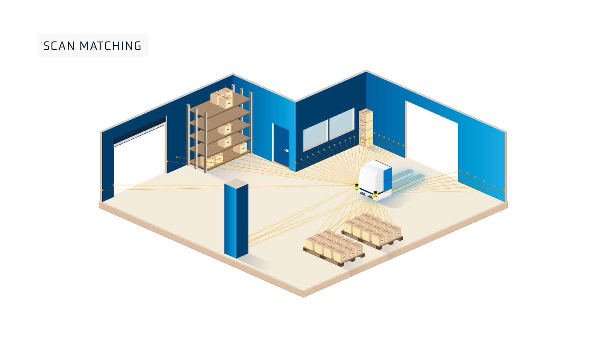
How scan matching works
With scan matching technology, measurements from the vehicle’s laser scanners are compared (matched) to the cells of a grid-based reference map of the environment. These cells can be compared to pixels in a digital image.
To position (localize) itself in the map, the navigation system calculates the vehicle’s position using the matched points. At the same time, it uses odometry, which measures the vehicle’s change in position by computing its movement. In rare cases, a scan matching system will regularly update the reference map with what the vehicle has ‘seen’.
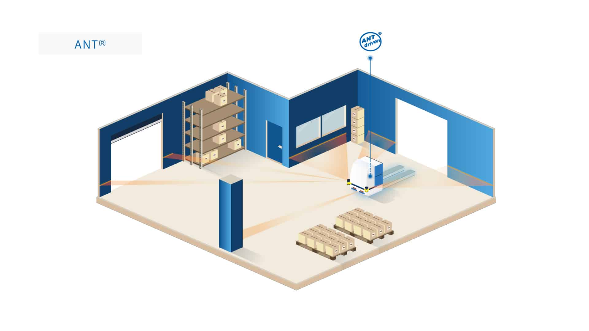
How feature matching works
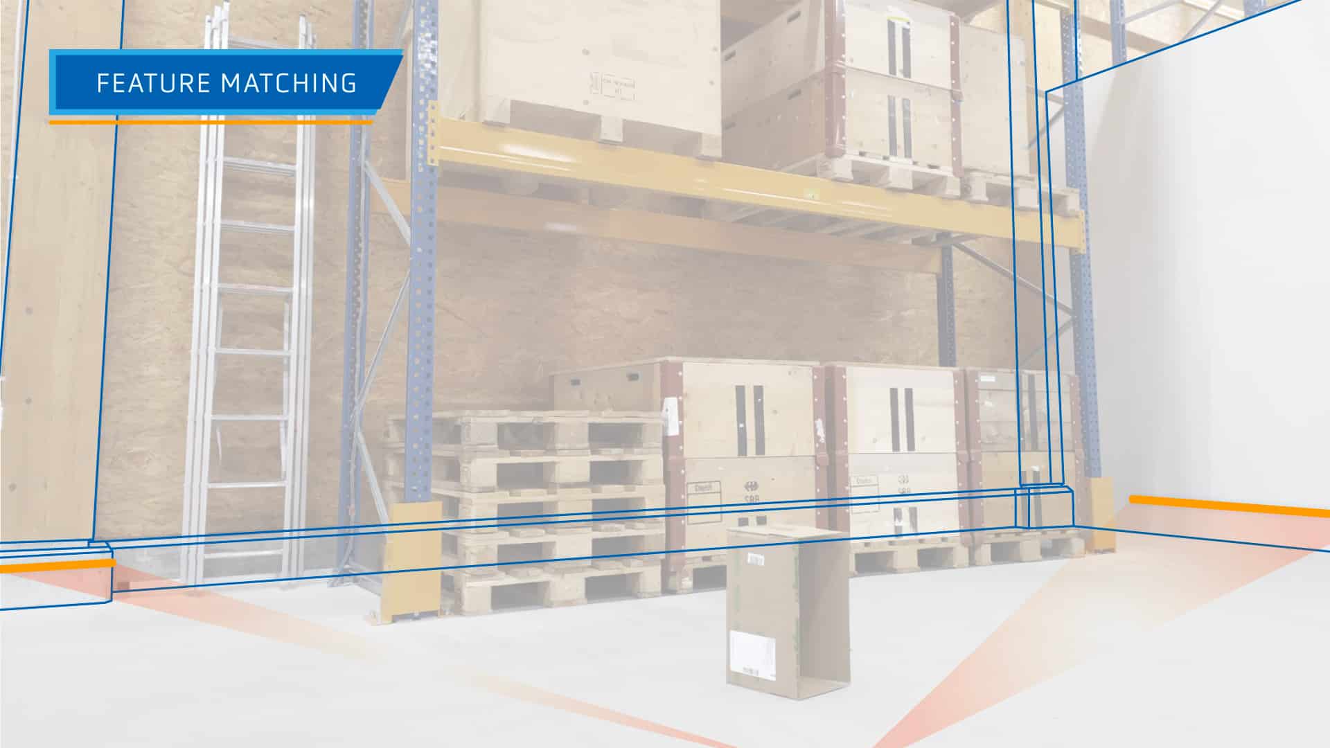
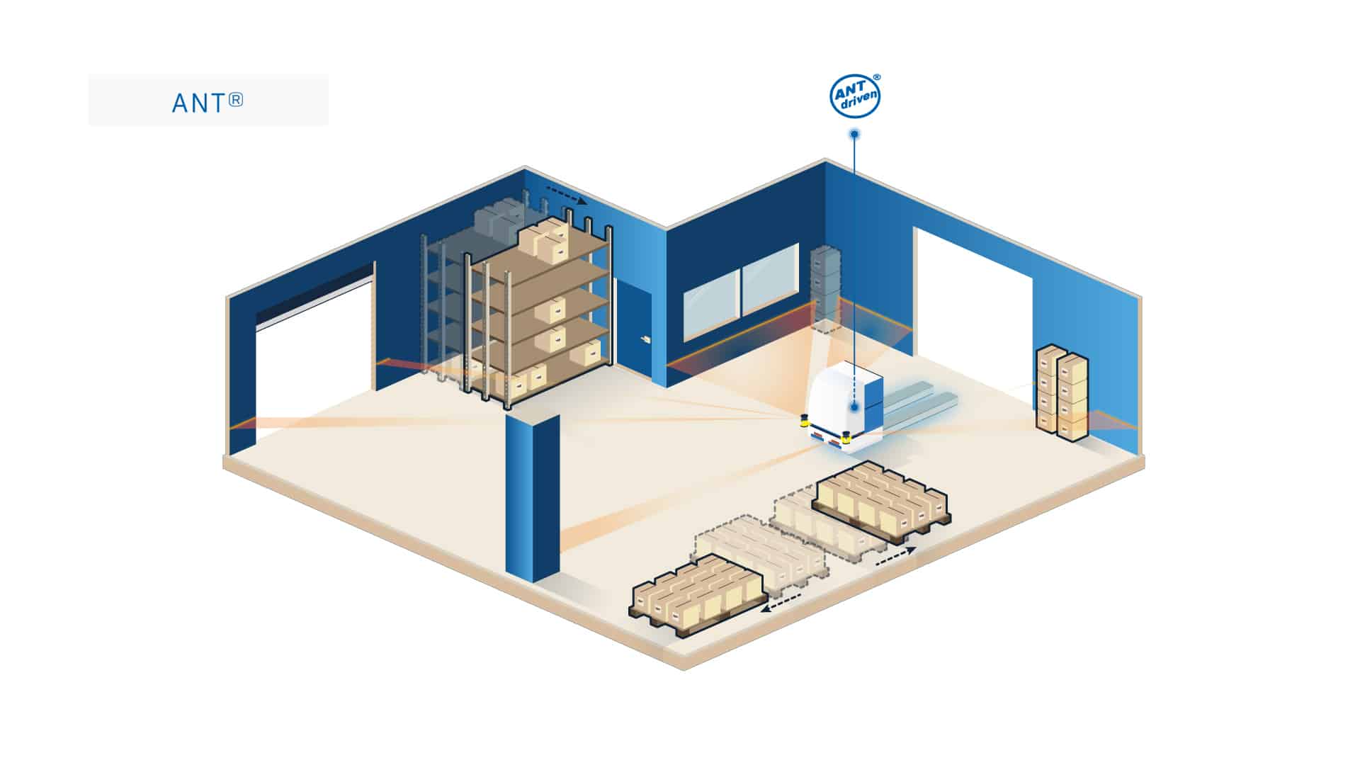
With ANT feature matching technology, measurements from the vehicle’s laser scanners are compared (matched) to permanent map references (features) such as walls and pillars. Should part of a site not have enough distinctive features, reflective stickers can also be added to provide additional references.
A key benefit of matching features, rather than laser points, is that features are highly distinctive due to the specific size and angle of each. They are therefore simple for the system to identify and successfully match.
To localize the vehicle in the map, ANT then uses a mix of odometry and feature matching, excluding all impermanent ‘dynamic’ objects (such as pallets, boxes, people and so on) from its calculations.
Because the resulting map contains only the coordinates of static, permanent features, it is much smaller in terms of file size than a grid-based map used by scan matching.

Can a vehicle navigate accurately without seeing everything?
Both vehicles using feature matching and those using scan matching technology need to ‘see’ and match features in the environment to localize themselves accurately.
But the proportion of environmental features they need to match varies dramatically:
- Scan matching technology needs to recognize at least 60% of the environment for accurate positioning.
- Feature matching technology needs to recognize 5% or less of the environment for accurate positioning. In fact, even if no features are matched for several seconds, ANT driven vehicles can navigate effectively for a few meters thanks to their use of odometry.
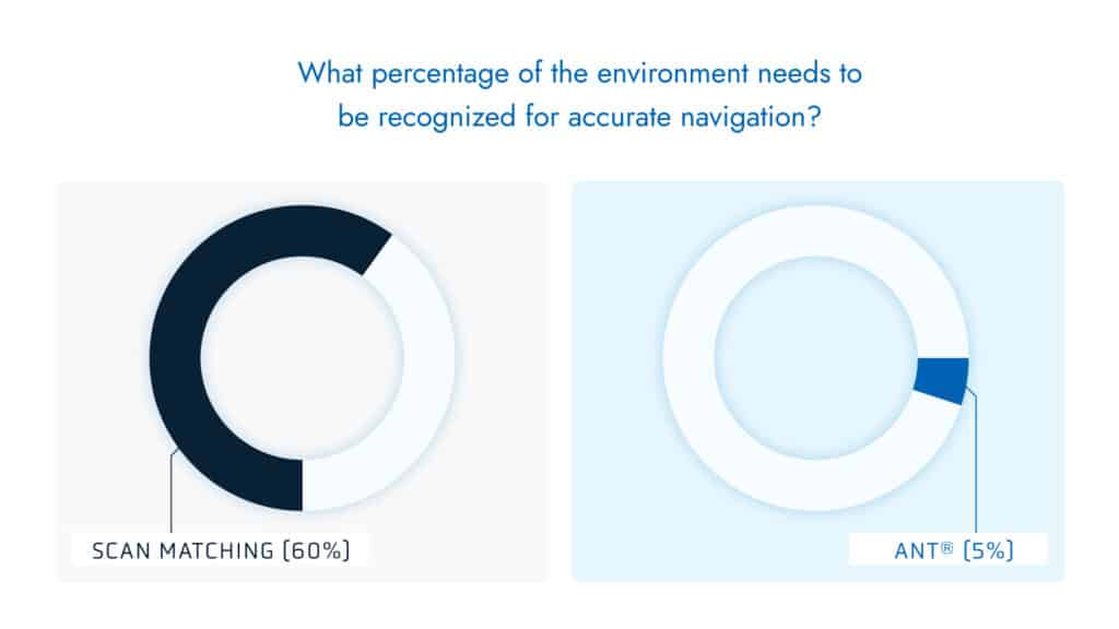
Therefore, ANT driven vehicles only need to recognize a small percentage of the environment in order to navigate effectively.
Where are an AGV’s navigation scanners located?
Most feature matching (ANT driven) vehicles do not use a dedicated laser scanner to navigate: instead they rely on their built-in safety laser scanners which are located at the base of the vehicle.
Feature matching vehicles will therefore detect unexpected objects such as a new stack of pallets – and the safety system will avoid collisions – but these dynamic objects will not be added to the vehicle’s map, as discussed above.

However, vehicles using scan matching often feature an additional laser scanner. This is usually positioned at the top of the vehicle to ensure as many points in the environment can be matched as possible.
Disadvantages of using an additional laser scanner
- Using an additional scanner adds an additional component cost for the vehicle maker (and likely a higher end price for the vehicle buyer).
- Each additional piece of hardware adds one more potential point of failure.
- Placing laser scanners at the top of the vehicle also restricts the types of vehicles a producer can offer to the market. For example, using a separate scanner for navigation does not enable a vehicle maker to produce low underride or ‘mouse’ type AGVs that are designed to move underneath carts.
- Lasers placed high on the vehicle are more sensitive to tilting or yawing caused by uneven surfaces or soft tires.
Is internet connectivity required for AGVs using natural navigation?
With feature matching, the map a vehicle uses never needs to be updated unless permanent features in the environment change. Therefore, ANT driven vehicles do not need strong, consistent wifi access to run. BlueBotics customers report that “spotty” on-site wifi (or Bluetooth or other wireless communication) is often sufficient. Low bandwidth connectivity is only required for server-led interactions, such as when vehicles interface with equipment (elevators, automatic doors), and for traffic control.
In comparison, if a vehicle uses scan matching technology that regularly updates the map, this requires strong, consistent wireless connectivity (not always the case in warehouses and on shop floors). This is because each updated map must be downloaded by each vehicle in the fleet from a central server, ideally in close to real-time. Remember, these incredibly detailed grid-based maps can have very large file sizes.
Which is more accurate – scan matching or feature matching?
It is not easy to ensure the repeatability and reliability of an AGV’s operations using natural navigation. However, ANT achieves this repeatedly over time and without losing accuracy (approx ±1 cm / ±1°).
The precision of scan matching’s vehicle localization is comparable to the cell size of its reference map. To reduce file size, vehicles using scan matching often downgrade their maps, creating cell sizes between three and ten centimeters. This is not a limitation faced by ANT driven vehicles as the reference map, containing only permanent features, is a smaller file size and does not need to be downgraded.
Additionally, because scan matching registers the entire environment – looking for matches – it also captures dynamic objects, which can move. For example, pallets may be regularly placed in one section of the loading dock. If they are always placed in exactly the same position, with centimeter accuracy, this would not cause any issues. But this is rarely the case. Therefore, if these pallets are placed a few centimeters out of alignment, the vehicle may assume they are in the correct place, and adjust the rest of the map accordingly, anchoring the map to the incorrect placement and making every other point within it inaccurate.
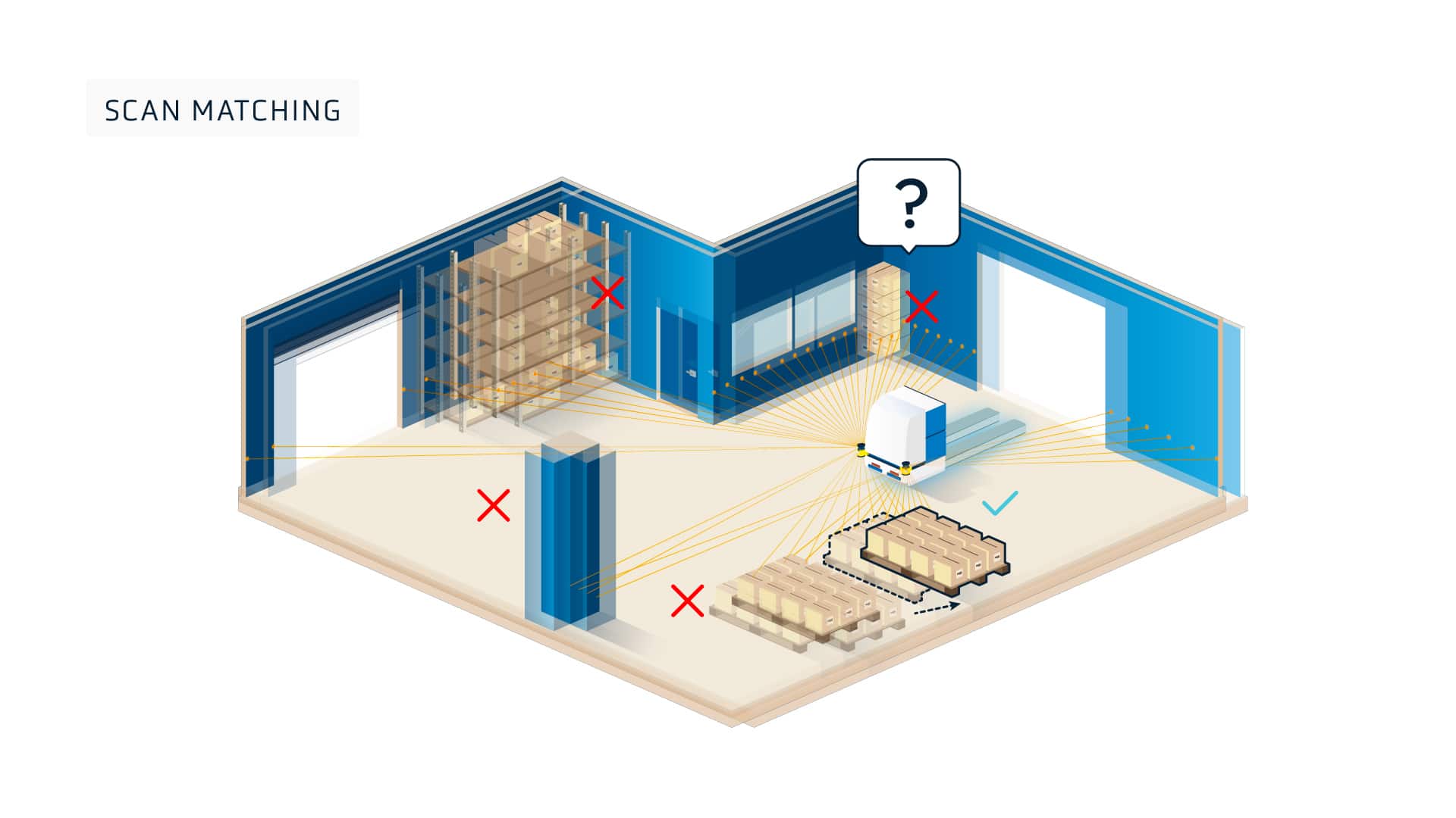
If a vehicle using scan matching navigation updates the reference map with readings that are intrinsically imprecise, any errors will be uploaded to the system’s vehicle management server and the updated map downloaded to the rest of the fleet, potentially spreading and compounding the error.
In the same example, an ANT driven vehicle would not record the location of the pallets at all. It would ignore them unless it is instructed to interact with them.
If a vehicle ignores dynamic parts of the environment, will that cause collisions?
For localization purposes, ANT driven vehicles are programmed to ignore objects in the environment that do not correspond to (match) the static features in the map. This can be thought of like driving a car on a highway: objects beyond the highway (like houses and trees) can simply be ignored. But what happens if an object appears in the vehicle’s path? Will there be a collision?
> Related: Myth – Obstacle Avoidance Always Means Greater Efficiency
Which natural navigation technology should you choose?
Each business has its own unique challenges. But for ease of use, accuracy and the robustness in operation, we believe ANT navigation is the clear choice for any vehicle type.
Watch our recent webinar to take a deeper dive into more navigation technologies (including line following and tag following). Or reach out to us with any questions about how ANT can help your business grow.
Let's get Started
Take the first step to automating your vehicle.
Schedule a call with our expert team today.