 Skip to content
ANT everywhere
开创AGV和 AMR 运营新时代

简单
在车辆各处安装 ANT 非常简单。唯一的额外步骤是:在现场添加一个 GNSS 基站。
无缝
得益于先进的传感器融合技术,可在室内和室外环境之间无缝切换。
灵活
ANT everywhere 与所有 ANT 导航产品兼容:lite+、localization 和 localization+。
精确
有了 ANT everywhere,室外 AGV 的操作与室内一样精确(±1 厘米/±1°)。
运用
ANT everywhere 使 AGV 制造商能够满足许多新的应用需求,但其中有两个关键用例最为突出:
- 在建筑物之间移动有效载荷(例如,在钢铁和铝生产中经常需要)。
- 在物流和生产场所之间移动有效载荷(在轮胎生产等行业中,物流和生产操作通常位于独立、不相连的建筑物内)。
行业

航空航天

机场

汽车

农业

采矿

造纸和纸浆

金属

风力涡轮机/近海风力
ANT everywhere - 开创农业电视新时代 和 AMR 运营
它是如何共工作的
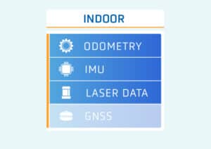
1 | A 所有传感器同时运行un simultaneously
ANT 的所有定位数据源(里程测量、激光数据、IMU 以及 GNSS 和 RTK 定位)都同时运行,称为传感器融合。然后,ANT 采用最相关的数据。
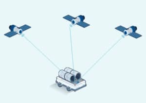
2 | 车辆接收到的GNSS全球导航卫星系统信号。
每辆配备了ANT everywhere的车辆都配有一个GNSS全球导航卫星系统接收器,可直接从卫星接收全球导航卫星系统的定位数据。
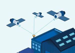
3 | 固定基站发送校正
(如在建筑物屋顶上)
安装在现场的固定基站也会接收来自GNSS全球导航卫星系统卫星的定位和定时数据。然后,该基站将对这些 GNSS 数据的 "修正 "发送到车辆的 ANT everywhere 接收器,将 GNSS 通常的约 3 米精度转换为约 1 厘米。
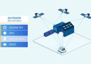
4 | ANT 融合所有可用数据
ANT 采用当时最相关的数据(GNSS全球导航卫星系统、激光等)。
